Wondering where Dubai is and how not to get lost once you're there? Finding an accurate map of Dubai and pinpointing its geographical location can be a challenge. In this practical guide, we'll take a closer look at Dubai and the United Arab Emirates, with thematic maps, interactive maps and all the practical information you need to prepare your trip.
Without losing sight of its strategic position in the world and its neighbourly relations with Abu Dhabi and Oman. You've been dreaming about it? We'll even tell you how to spot the Burj Khalifa with your eyes closed!
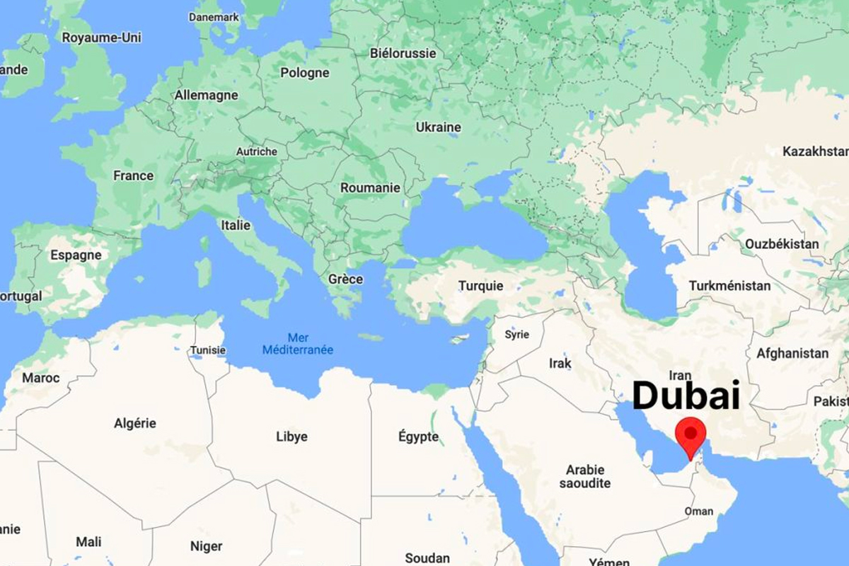
Where is Dubai on the world map?
Where is Dubai on the world map? A question that deserves some clarification. This metropolis in the Arab Emirates plays a key role on the international stage. But let's take a closer look, with a few concrete illustrations.

On which continent can you find Dubai? The answer seems simple: in Asia, or more precisely in the Middle East. Its geographical layout places it on the southeastern shore of the Persian Gulf, an ideal position for trade. Dubai is part of a federation of seven emirates. The United Arab Emirates stretch across the Arabian Peninsula, between Saudi Arabia to the west and the Sultanate of Oman to the east.

Why is this international hub so fascinating? Thanks to a clever blend of geostrategy and ambition. The city has become a hub of world trade, serving as a bridge between Europe, Asia and Africa. Its ultra-modern airport and stalwart political news attract investors and tourists alike. See our practical guide for photos and images of the city's dynamism. And its privileged location makes it an essential landmark on any modern economic map. A true crossroads of civilizations, where Arab traditions meet futuristic innovations.
Maps and charts to understand Dubai
To really capture the soul of Dubai, nothing beats a detailed map or a precise plan. But how do you choose between digital and paper options? Our guide explains!
Thematic maps of the emirate
Specialized maps are indispensable for exploring the many facets of Dubai. They help you organize your stay according to neighborhoods and activities. Here's a comparative table that sums up the essentials:
| Neighborhood | Description | Main attractions |
|---|---|---|
| Downtown Dubai | Busy heart of the modern city. | Burj Khalifa, Dubai Fountain, Dubai Mall, Dubai Opera House |
| Dubai Marina | Seaside ambience, prices slightly lower than Jumeirah. | Marina Promenade, Beaches, Restaurants |
| Al Barsha | Close to tourist attractions and family amenities. | Mall of the Emirates |
| Palm Jumeirah | Family-friendly neighborhood, safe, international schools. | Atlantis Aquaventure Waterpark, Restaurants, Shopping malls |
| Deira (Old Dubai) | A must for traditional shopping. | Gold Souk, Spice Souk |
| Bluewaters | Modern neighborhood on a man-made island. | Ain Dubai (Ferris wheel), The Beach (via pedestrian bridge) |
| Bastakiya (Old Dubai) | Authentic historic district. | Dubai Fort Museum, Al Bastakiya Iranian Quarter |
Theemirate 's expansioninto coastal and arid areas is well worth a closer look. To visualize this metamorphosis, satellite photos are better than a long speech.
Local maps with visual codes are clever. Did you know that artificial islands resembling palm trees indicate Palm Islands? These markers simplify orientation in this urban maze. A good plan to memorize the symbols before setting off to explore theemirate.
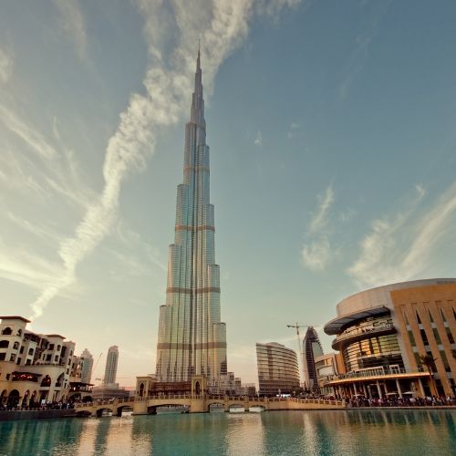
The 3D versions of the plans help to convey the sheer scale of Dubai's skyscrapers. The Burj Khalifa takes on its full dimension, literally dominating the landscape. Handy for visualizing the distances between monuments!
Practical navigation tools
We recommend these resources for stress-free travel:
- Google Maps: although the results don't detail Dubai-specific features, Google Maps is a widely used mapping application and can be useful for general navigation, whether by car, public transport or on foot.
- Dubai 360: this app offers an immersive virtual tour of Dubai's lesser-known districts and sites, enabling visitors to discover places off the beaten track and plan their itineraries accordingly.
- Public transport apps: to make your journey easier, download apps providing real-time information on Dubai's metro, bus and streetcar schedules and routes.
- VTC apps: apps like Careem and Uber are popular in Dubai for getting around quickly and easily, especially if you prefer not to drive or use public transport.
? GOOD TO KNOW
A little tip: the government's interactive maps even include electric recharging stations. Handy for drivers!
Google Maps becomes even more useful with its "photographed places" filters. With one click, spot the most photogenic spots thanks to photos shared by travelers. An under-used feature that's a game-changer.
Beware of remote areas: GPS sometimes shows its limitations near the borders withneighbouring Arabia. In such cases, it's best to rely on a paper map and... a good old-fashioned sense of direction!
Key geographical elements
The Persian Gulf has a direct influence on the emirate's urban planning. The 70 km of coastline determine the location of residential areas. The balance between urbanization and arid environment is always surprising. Lush parks and dunes coexist here like nowhere else in the Arab Emirates. A paradox that partly explains the country's appeal.
The political borders with Abu Dhabi and the other emirates determine administrative practices. It's best to be familiar with them before venturing into the farthest reaches of the territory!
Geopolitical environment
To understand Dubai 's place in the region, its geopolitical context is worth a closer look. But where to start? Follow our guide for an overview of local and international relations.
Neighbouring countries and emirates

Dubai shares its land borders with Abu Dhabi and Sharjah. Did you know that maritime delimitation plans in the Persian Gulf directly influence its economy? Management of fishing resources, trade routes... these are all challenges where every pixel on the map counts. The Emirates have developed innovative practices to manage these sensitive areas, as shown by the latest official satellite images.
On the Omani side, land crossings facilitate trade. These strategic routes, clearly marked on road maps, strengthen the links between the Gulf countries. Cooperation based on up-to-date information and shared protocols.
Regional cooperation
Trans-Emirane projects show the extent to which the region is committed to integration. Take transport: harmonized standards, interconnected networks... These concrete illustrations of a proactive policy are now setting the standard. The Arab Emirates even share a master plan for their key infrastructures, available online with explicit visuals.
Natural resource management? Another area of collaboration. The Emirates have set up a joint monitoring system, enhanced by regular aerial photography. An approach that combines Bedouin tradition and modern technology, as demonstrated by their richly illustrated annual reports.
International positioning
Dubai functions as a veritable hub between continents. Its airport and seaport - visible on all the world's logistics maps - make it a hub for global trade. An interesting comparison: whileSaudi Arabia relies on its oil power, the emirate pragmatically diversifies its assets.
Recent data also show a notable evolution. According to the Numbeo index, the city recently moved up from 210th to 217th position among the world's most expensive cities.
Historically, maritime trade has shaped this destiny. The British colonial archives are full of old maps showing the early development of the port of Dubai. These historical documents, now digitized, offer a fascinating insight into the roots of today's success story.
Spatial distribution of the population
How are Dubai' s inhabitants distributed? Between overcrowded skyscrapers and stretches of desert, the territory tells an astonishing story. Follow our guide to decipher this unique organization.
Urban density and desert
The contrast between hypercentre and periphery is striking.
Local urban planning policies seek to reconcile expansion and ecology. A real headache when you consider the Gulf 's climatic challenges! Take the Dubai Water Canal: this flagship project boosts tourism but requires environmental precautions. Recent news reports show a tightening of environmental standards.
Did you know that communities still live in oases? These islands of greenery in the middle of the sands illustrate ancestral adaptation to local constraints. Ingenious farming techniques have been passed down for generations.
Key transport networks
The Dubai Metro is the emirate's vital artery. Just imagine: this blue line on the urban map enables rapid connections between key areas. Convenient for workers in the logistics sector.
Airports aren't just for travelers. Their connection to industrial zones via the metro creates a unique economic ecosystem. Further proof that the Emirates have mastered the art of XXL infrastructures.
Coastal developments and artificial islands
Dubai's maritime extensions defy the laws of nature. But at what ecological cost? Satellite images show the impact of the Palm Islands on marine currents. Fortunately, engineers have incorporated underwater corridors to preserve biodiversity.
Dubai's old port is being transformed into a trendy district. This intelligent urban recycling avoids sprawl while preserving heritage. A lesson in urban planning for many Gulf countries!
Distribution of essential services
Where to locate hospitals and schools in this contrasting landscape? Urban planners are playing a balancing act. The map of public services shows a concentration on the coastal axis, with inland areas sometimes lagging behind.
Power grids, wastewater treatment plants... these invisible infrastructures keep Dubai's machine running. An ongoing technical challenge as the city expands. Abu Dhabi shares some innovative solutions with its neighbor.
On the outskirts of the city, access to health care can be complicated. However, the authorities are deploying mobile clinics - an initiative which, according to several local observers, deserves to be extended.
Coordinates and spatial references
How not to get lost in Dubai? Geographical coordinates and spatial references are your best allies in this ever-changing emirate. Follow the guide as we explain how to master local reference systems!
Coordinate systems used
Don't panic when faced with conversions between geodetic standards: everything can be learned.
The WGS 84 system dominates here, as it does for your smartphone GPS. This universal location format allows you to pinpoint any place on a map with frightening accuracy. In Dubai, you'll come across it in navigation apps, online maps and land management systems. A practical detail: coordinates are displayed in either decimal degrees or degrees-minutes-seconds.
Local cadastral maps are full of surprises. A veritable mine of strategic information, they show property boundaries, land use rights and other legal details. Indispensable for real estate projects or administrative procedures, these official documents are often consulted with the help of a professional.
Major geographical landmarks
The Burj Khalifa isn't just a height record: it's also a giant compass! Visible for miles around, this iconic tower serves as a natural landmark for navigating the metropolis. It's a trick that locals use on a daily basis.
Telecom towers play a key role in the location system. These structures, scattered across the emirate, not only provide mobile network reception, but also refine your position on digital maps. An infrastructure that is often invisible... but so useful!
Historical navigation methods
Did you know that the Bedouins crossed the sandy expanses without GPS? Their secret: an intimate knowledge of the stars, dunes and waterholes. These ancestral navigation practices, transmitted orally, even included wind observation to anticipate storms.
The evolution of maritime tools tells the story of a fascinating technical adventure. From the first compasses to precision sextants, each innovation has pushed back the limits of navigation. Ancient nautical charts, sometimes adorned with legendary monsters, show how the perception of Arab coasts has evolved over time. Today, GPS has changed everything... but the charm of old nautical grimoires persists!
Practical tip: To explore Dubai like a pro, combine modern navigation tools with satellite images. Always keep a few photos of visual landmarks on your smartphone - they can come in handy!
How to decipher Dubai's maps
Want to master Dubai's maps like a pro? Knowing how to interpret them correctly makes all the difference when it comes to exploring this emirate and avoiding the pitfalls. Here's a step-by-step guide to stress-free navigation.
Color codes on tourist maps? They're your best ally. For example, brown often indicates historic sites, while green shows green spaces. A good local guidebook usually includes a detailed legend - be sure to consult it before you set off.
Some typically Arab symbols may come as a surprise. Mosques sometimes appear as stylized minarets, and souks with a basket icon. For political news, look for the Emirates' golden falcon - it also graces official buildings in Abu Dhabi.
Don't worry about the legends! Most modern maps offer English translations. The Gulf authorities are working to harmonize pictograms for travelers. A paper guide is still useful - supplement it with recent satellite photos to locate new districts.
Thematic maps
Looking for a new way to discover Dubai? Thematic maps are your best ally! These tools offer you a targeted reading of theemirate, highlighting specific aspects: economic zones, logistics networks or even tourist affluence. Are you in the mood for a visual guide to exploring Dubai in a different way?
The map of free economic zones is an essential tool for deciphering Dubai's attractiveness. These zones offer companies tax advantages that boost investment. By studying their distribution on the map, we can better understand howArabia has positioned its strategic economic hubs. An invaluable guide for professionals!
An analysis of the region's logistics infrastructure reveals its economic inner workings. These maps detail ports, airports and major roads - key information for optimizing trade flows. Did you know that theemirate of Abu Dhabi boasts one of the most efficient logistics hubs in the Gulf?
Heat maps of tourist traffic can save you a lot of hassle. They point out saturated areas and lesser-known corners, enabling you to put together your own customized visit plan. Why not alternate between iconic sites (with their breathtaking photos) and authentic places? A clever approach to taming Arabia in all its facets.
For example, the interactive map of Dubai Creek blends historical illustrations with modern data. You'll come across both archival images and practical information on today's souks. The perfect combination of discovery and organization!
Localization technologies
How are our smartphones redefining the way we discover Dubai? From GPS to augmented reality, our guide to new tools will show you how these technological innovations are being integrated into everyday life. Did you know that the city's interactive map now combines drones and satellites? Let's take a look at what this means for your travels.
Geolocation systems
GPS accuracy in the emirate is excellent, thanks to optimal satellite coverage. In fact, it is neighboringSaudi Arabia that has shared certain military mapping technologies adapted here for civilian use.
Dhabi's famous police robot? This project, born in the emirate's laboratories, uses these very systems to patrol. With its nine spoken languages, it relies on real-time maps updated every hour.
Drone mapping
Beware of preconceived ideas: since 2025, mapping practices have evolved. While overflights still require authorization, professionals can capture detailed aerial images to update the emirate's official map.
Local police use these flying machines for much more than just surveillance. Their latest innovation? 3D reconstruction of historic souks using high-definition aerial photos. A real plus for tourist guides!
Augmented reality navigation
Try out the official tourist office app: point your smartphone at a building, and superimposed historical illustrations appear. This contextual information turns any stroll into an interactive guided tour.
The icing on the cake - these tools integrate seamlessly with the transport network. One click on your interactive digital map not only shows you the route, but also the actual bus timetable or the expected queues at attractions.
Open data cartography
Political transparency through data can also be measured: the emirate's official portal now offers geolocalized information.
Citizens are actively involved: reporting potholes via the app, creating collaborative maps of food trucks... A modern way of shaping the participatory urban plan. Can you imagine adding your own contribution on your next visit?
Map evolution
How will Dubai's skyline change over the coming decades? Between territorial extensions, climatic adaptations and technological advances, the challenges are sure to be stimulating. Let's decipher the trends that will reshape the emirate's map.
Territorial expansion projects
The Dubai Master Plan 2040 outlines an ambitious vision for the emirate.
The rise of smart cities is revolutionizing urban planning. Thanks to ongoing data analysis, interactive maps are becoming veritable dashboards for managing traffic and public services. These tools help residents and authorities alike to make informed decisions for their conurbations.
Representing Dubai's mega-projects poses a technical challenge. 3D images and augmented reality now offer more immersive visualizations, enabling us to better apprehend the impact of these pharaonic worksites on the emirate's landscape.
Adapting to climate change
Coastal risk modeling is becoming a key issue for Dubai.
Flood vulnerability maps serve as a basis for preventive policies. They identify sensitive areas and guide the construction of dykes or buffer zones. A crucial issue for Dubai in the face of rising sea levels.
Urban development must now take climate parameters into account. In Dubai, master plans explore solutions such as resilient buildings and green corridors. Cartographic illustrations help visualize the impact of heat islands and plan energy infrastructures.
New mapping trends
AI is transforming navigation systems, especially in Dubai.
Real-time traffic monitoring is proving its worth on a daily basis. By avoiding traffic jams thanks to these dynamic maps, drivers save precious time. The emirate's authorities use this information to improve traffic flow on strategic roads.
The use of mobile data opens up unprecedented possibilities. By analyzing people's movements, Dubai's urban planners are optimizing transport networks. These innovative practices use mobile heat images to rethink regional planning.
Every update of the official plans is available on the emirate's geographic portal. Recent aerial photos and 3D illustrations reveal the extent of the transformations underway in this region of Arabia.
Now that you've learned all about Dubai's maps, geography and environment, what's next? Don't wait too long to plan your trip - go and see for yourself how this world-city defies deserts. Still not sure? Remember: every street here tells a story between dunes and skyscrapers. It's the perfect time to take the plunge!
FAQ
Is Dubai a country?
No, Dubai is not a country. It's a city and an emirate, part of the United Arab Emirates (UAE), a federation of seven emirates.
The United Arab Emirates is a country in the Middle East, bordered bySaudi Arabia and the Sultanate of Oman. Dubai is the capital of the Emirate of Dubai.
Where is Dubai?
Dubai is located on the Persian Gulf coast in the Middle East. It is bordered bySaudi Arabia to the west and south, and by the Sultanate of Oman to the east.
More precisely, Dubai is the second-largest emirate of the United Arab Emirates, located on the southern shores of the Persian Gulf. Neighboring emirates are Charjah and Ras el Khaimah to the northeast, and Abu Dhabi to the southwest.
Is Dubai a capital?
Dubai is the capital of the Emirate of Dubai, one of the seven emirates that make up the United Arab Emirates.
Abu Dhabi is the political capital of the United Arab Emirates, while Dubai is the economic center.
Which country is close to Dubai?
Dubai is bordered bySaudi Arabia to the west and south, and by the Sultanate of Oman to the east. Dubai is one of the seven emirates of the United Arab Emirates (UAE), a country located in the Middle East.
Dubai's neighbouring countries are Oman andSaudi Arabia. Abu Dhabi, the federal capital, is a short distance from Dubai.


")